- Home
- Admin
- Meetings
- Fry-Ark Project
- Projects
- Water Management
- Agriculture Conservation
- Arkansas River Basin Water Rights
- Conservation Plans
- Conservation & Education
- Education
- Fryingpan-Arkansas Project Water Import Tracking
- Inclusion into the Southeastern Colorado Water Conservancy District
- Legislation
- The Allocation of Fryingpan-Arkansas Project Water & Project Water Return Flows
- RRA
- Snow Pack Monitoring
- Water Conservation BMP Tool Box
- Winter Water Storage
- Water Wise Gardening
- Login
Snow Pack Monitoring
The Southeastern Colorado Water Conservancy District (District) monitors the snowpack of the Arkansas and Upper Colorado River basins. The purpose is to have the ability to present this information to its Board of Directors, constituents, and partners in a graphical format that illustrates both of the basins and the areas specific to the Fryingpan-Arkansas Project (Project) and the areas of the Arkansas basin within the District. This information is used as an indicator of the amount of Fry-Ark Project water that may be available for allocation.
The U.S. Department of Agriculture - Natural Resources Conservation Service (NRCS) has “Snow Survey & Water Supply Forecasting Programs” covering the eleven contiguous western states and Alaska.
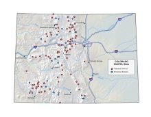
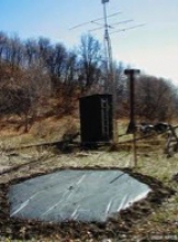
The snowpack is measured using SNOTEL (SNOWpack TELemetry) sites.
“Snow Survey & Water Supply Forecasting Program Brochure"
 |
 |
 |
 |
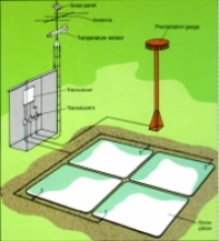
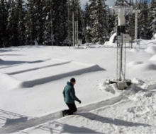
SNOTEL sites and the associated Snow Pillows that measure the water content of the snow (Snow Water Equivalent or SWE) by weighing the snow on the pillow.
The District obtains daily “NRCS Snow Water Equivalent” information to determine the current amount of Snow Water Equivalent in a watershed. The Snow Water Equivalent of specific sites is compared to historical high, low, average, and median amounts of Snow Water Equivalent.
Examples of graphs from the hyperlink for the Arkansas and Colorado basins are shown below:
- December 22, 2021
- June 2, 2021
- May 26, 2021
- May 12, 2021
- May 5, 2021
- April 28, 2021
- April 21, 2021
- April 14, 2021
- April 7, 2021
- March 31, 2021
- March 24, 2021
- March 17, 2021
- March 11, 2021
- March 3, 2021
- February 24, 2021
- February 17, 2021
- February 10, 2021
- February 3, 2021
- January 28, 2021
- January 22, 2021
- January 13, 2021
- January 6, 2021
- December 30, 2020
- December 23, 2020
- June 3, 2020
- May 27, 2020
- May 20, 2020
- May 14, 2020
- May 6, 2020
- April 29, 2020
- April 22, 2020
- April 15, 2020
- April 8, 2020
- April 1, 2020
- March 25, 2020
- March 17, 2020
- March 11, 2020
- March 4, 2020
- February 26, 2020
- February 19, 2020
- February 12, 2020
- February 5, 2020
- January 28, 2020
- anuary 22, 2020
- January 15, 2020
- January 10, 2020
- January 2, 2020
- December 27, 2019
- December 19, 2019
- December 12, 2019
- December 05, 2019
- November 27, 2019
- May 29, 2019
- May 22, 2019
- May 15, 2019
- May 8, 2019
- May 1, 2019
- April 25, 2019
- April 18, 2019
- April 10, 2019
- April 3, 2019
- March 27, 2019
- March 20, 2019
- March 13, 2020
- March 6, 2019
- February 27, 2019
- February 20, 2019
- February 13, 2019
- February 6, 2019
- January 29, 2019
- January 23, 2019
- January 15, 2019
- January 2, 2019
- December 27, 2018
- December 19, 2018
- December 5, 2018
- May 23, 2018
- May 16, 2018
- May 9, 2018
- May 2, 2018
- April 27, 2018
- April 18, 2018
- April 11, 2018
- April 5, 2018
- March 29,2018
- March 22,2018
- March 14, 2018
- March 7, 2018
- February 28, 2018
- February 14, 2018
- February 7, 2018
- January 31, 2018
- January 17, 2018
- January 10, 2018
- January 3, 2018
- December 27, 2017
- December 20, 2017
- June 1, 2017
- May 24.2017
- May 18, 2017
- May 11, 2017
- May 4, 2017
- April 26, 2017
- April 19, 2017
- April 12, 2017
- April 5, 2017
- March 29, 2017
- March 22 ,2017
- March 15, 2017
- March 8, 2017
- March 1, 2017
- February 22, 2017
- February 16, 2017
- February 8, 2017
- February 1, 2017
- January 27, 2017
- Janaury 19, 2017
- January 5, 2017
- June 01, 2016
- May 19, 2016
- May 11, 2016
- May 4, 2016
- April 20,2016
- April13,2016
- April 7, 2016
- March 30, 2016
- March 23, 2016
- March 16, 2016
- March 9, 2016
- March 2, 2016
- February 24, 2016
- February 17, 2016
- February 10, 2016
- February 3, 2016
- January 27, 2016
- January 20,2016
- January 13, 2016
- January 6, 2016
- December 30, 2015
- December 23, 2015
- December 16, 2015
- December 9, 2015
- December 2, 2015
- November 19, 2015
- June 10, 2015
- June 3, 2015
- May 27, 2015
- May 20, 2015
- May 13, 2015
- May 6, 2015
- April 29, 2015
- April 22, 2015
- April 15, 2015
- April 8, 2015
- April 1, 2015
- March 25, 2015
- March 18, 2015
- March 11, 2015
- March 4, 2015
- February 25, 2015
- February 18, 2015
- February 11, 2015
- February 4, 2015
- January 28, 2015
- January 21, 2015
- January 14, 2015
- January 7, 2015
- December 31 ,2014
- December 23, 2014
- December 17, 2014
- December 10, 2014
- December 3, 2014
- June 11 2014
- June 4 2014
- May 28 2014
- May 21 2014
- May 14 2014
- May 7 2014
- April 30 2014
- April 23 2014
- April 16 2014
- April 9 2014
- April 3 2014
- March 26 2014
- March 12 2014
- March 4 2014
- February 26 2014
- February 19 2014
For monthly NRCS Colorado Basin Outlook Reports click here.
For the most current SNOTEL information regarding Colorado, click here.
