- Home
- Admin
- Meetings
- Fry-Ark Project
- Projects
- Water Management
- Agriculture Conservation
- Arkansas River Basin Water Rights
- Conservation Plans
- Conservation & Education
- Education
- Fryingpan-Arkansas Project Water Import Tracking
- Inclusion into the Southeastern Colorado Water Conservancy District
- Legislation
- The Allocation of Fryingpan-Arkansas Project Water & Project Water Return Flows
- RRA
- Snow Pack Monitoring
- Water Conservation BMP Tool Box
- Winter Water Storage
- Water Wise Gardening
- Login
Arkansas River Basin Water Rights

Download Arkansas River Line Diagram (pdf)
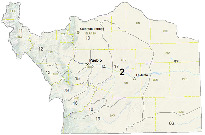
Water Division 2 in Colorado is all of the Arkansas River basin. The Basin Map shows the 13 Water Districts in Division 2. There are water commissioners that administer the water rights in their Water Districts, in coordination with the Division 2 Engineer’s Office.
The Regional Resource Planning Group, comprised of the Southeastern Colorado Water Conservancy District, the Upper Arkansas Water Conservancy District, the Lower Arkansas Valley Water Conservancy District, Colorado Springs Utilities, the City of Aurora, and the Board of Water Works of Pueblo commissioned the Applegate Group to develop the Arkansas River Basin Line Diagram (Line Diagram).
The full basin Line Diagram shows the major water rights on the Arkansas River and its major tributaries from the headwaters above Leadville to the Kansas border. The detailed Line Diagram of the six Water Districts schematically depict the Arkansas River and its tributaries with blue lines, the major canals and ditches with red lines, the exchange reaches with green lines, the Water District boundaries with dashed black lines and the county lines with pale purple lines.;The text boxes show the decreed water rights each ditches owns, and the associated flow and priority date of the right. If a ditch has acquired additional water rights or sold water rights, these decrees are also shown in the text boxes.
These Line Diagrams are a very useful tool in understanding the relative locations and priorities of ditches and exchange reaches as they relate to each other and the river system.
|
Line Diagrams |
 |